Source: Newsletter of the
North Manchester Historical Society
Volume XXI Number 4 November 2004
The Cemeteries of Pleasant and PawPaw Townships
 Chester Township boundary is Highway 13 on the west side
of North Manchester so many citizens of North Manchester
lie in cemeteries in Pleasant township. This is
especially true for Pleasant Hill, the Cripe cemeteries
and the Old German Baptist Brethren cemetery. This
report uses much information from Lester Binne's
Cemetery Records for Paw Paw and Pleasant Townships
Wabash County, Indiana.
Chester Township boundary is Highway 13 on the west side
of North Manchester so many citizens of North Manchester
lie in cemeteries in Pleasant township. This is
especially true for Pleasant Hill, the Cripe cemeteries
and the Old German Baptist Brethren cemetery. This
report uses much information from Lester Binne's
Cemetery Records for Paw Paw and Pleasant Townships
Wabash County, Indiana.
German
Baptist Brethren cemetery located about one half mile
north of the intersection of State Roads 13 and 114
along Highway 13. The land for the adjacent church and
the cemetery was donated by Henry Cripe and the first
burial is said to have occurred on February 7, 1885. A
number of stones were moved from other older cemeteries
in the community but likely no bodies were exhumed. The
cemetery is well cared for and currently used. Common
names found there Butterbaugh, Cripe, Metzger,
Blickenstaff, Renicker, Blocher, Frantz, Boocher, Long,
Miller, Ulrey, Karn, Heeter.
Pleasant
Hill Cemetery, located one mile west of the intersection
of State Roads 13 and 114. It is an endowed cemetery,
very well maintained and currently used. It joins the
church yard of the West Manchester Church of the
Brethren. This brick church is the second building to be
built on this site. The cemetery was established about
1880, but it contains several stones that were moved in
from other locations. Common names found in this
cemetery: Lautzenheiser, Heeter, Butterbaugh, Boyer,
Crill, Warner, Cupp, Ulrey, DeLauter, Penrod,
Blickenstaff, Frantz, Ohmart, Grossnickle, Harter,
Garber, Buckingham, Landis Brookins, Miller, Neher and
many others. Otho Winger, President of Manchester
College for thirty years and members of his family lie
in this resting place.
Old Cripe
Cemetery located on a hilltop about one mile west of the
intersection of State Roads 114 and 13 at North
Manchester, it is on the north side of Road ll4
overlooking Clear Creek. This stream was an important
mill stream in pioneer days. The cemetery is about 60 x
70 feet, fenced and now overgrown with native trees and
myrtle. All of the adult buried there are believed to
have been German Baptists. Some bodies may have been
moved to other cemeteries but it is not clear if bodies
were removed or only stones or perhaps only bodies and
not stones.
Common
names include Cripe, Butterbaugh, Boyer, Crill, Miller,
Albright, Myers, Frantz, Isenbarger, Karn, Grossnickle.
Rose Hill
Cemetery, sometimes known as the Lutheran or North
Pleasant Cemetery. Located on the south side of the
Wabash - Kosciusko County Line, near Wabash County Road
300 w. The cemetery and church yard occupy about an acre
of land. A stone, built into the red brick church
building reads, "North Pleasant Church, 1881. Common
names: Bussard, Oldfather, Isley, Penrod, Ayres,
Feigley.
Laketon
Cemetery, first known as the Ijamsville Cemetery,
located at the intersection of County Roads 950n & 200
w. about a half mile south of Laketon in Pleasant
Township, Wabash County, Indiana. The cemetery is on the
west side of 200 w and across the road from the
Christian Church, built in 1901. Common names are
Thompson, Bender, Fites, Fogerty, Tryon, Ogden, Kelly,
Grisso, Weaver, Knouf,Lautzenheiser, Wertenberger,
Sholty, Hoover, Moyer, Rager, Rooney, Werner, Palmer,
Lindsey, Pettet, Mylin, Sickafus, Ferry, Ulsh, Marshall,
Frederick and others.
Shiloh
Cemetery, located about one half mile north of the
junction of County Roads 700 w and 850 n in Pleasant
Township. This was, once, the location of a Presbyterian
church. The cemetery has had no maintenance for several
years and is overgrown with bluestem, a tall prairie
grass. It is fenced but many stones are broken or down.
Common names are Keim, Ulsh, Stanley, Chinworth, Larrew,
Brundige, Lukens, Schuler.
South
Pleasant Cemetery, located at the intersection of County
Road 1400 n and State Road 15. The east part is the
oldest and it is separated from the new part by a white
frame church now occupied by the United Methodist
denomination. The cornerstone shows: "Pleasant Church 25
June, 1874." Common names are Drudge, Ihnen, Hileman,
Young, Seitner, Leffel, Kroft, Jontz, Clinker, Gamble,
Miller, Haney, Rager, Dillman, Groninger, Eichholtz,
Hively. Shellenberger, Larrey, Noftzger, Weimer
Abshire
Cemetery located in an open field about 600 ft southwest
of the intersection of County Roads 600W &500 N in
Pawpaw township. The plot is about 50 feet square,
covered with bluegrass and several hickory trees. It has
been abandoned for many years and none of the stones are
standing. Most of them were found in a pile under one
tree. Abraham Abshire, 1800-1892, and his wife, Hannah
Neff were early settlers near Roann, Ind. They were
natives of Franklin County, Virginia, near Boones Mill.
Shelby Arthur came to this area from the same place and
at about the same time and were members of the German
Baptist church near Roann. Abraham was a son of Edward
Abshire and a grandson of Luke, both of whom died in
Franklin County, Virginia. Names, Abshire, Garver, Neff.
Alger
Cemetery, located about 2 and a half miles southeast of
Laketon on County Road 750N in Paw paw Township.
Beautiful and well kept on a hilltop about 300 feet
north of the road. There are two very large yellow
poplar tree near the entrance and four very large red
cedar in the enclosure. Common names Baker, Poole, Baer,
Alger, Sickafus.
Gamble
Cemetery, located 2 miles south of Roann, just east of
the intersection of County Roads 400s & 700 E. in Paw
Paw Township. This cemetery is completely overgrown with
myrtle and rose briers. It is fenced except on the side
next to the road. Names; McCoy, Bryan, Gamble.
Jack
Cemetery, located about a half mile east of County Road
600W and about a half mile south of County Road 500 N on
the south wide of Paw Paw creek. It appears to have been
in use from about 1840 to 1914 but is now subject to
grazing livestock. It is said that some stones were
removed to the I.O.O.F. cemetery north of Roann. Names:
Flint, Oswalt, Garver, Jones, Watson, Jack, Denning,
Boblet.
Long
Cemetery, located two Miles west and about one mile
south of Urbana, on the west side of County Road 200W on
the south side of Paw Paw creek. This cemetery in very
poor condition. Names: Watts, Baker, Dunfee, Gray,
Latchem, Long, Wellman, Lambert, Freeman, Purdy, Guynn,
Amber,Merrick, Alger, Siders, Slee.
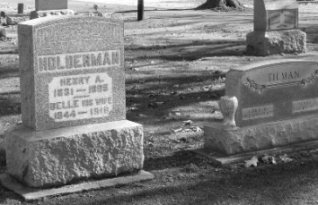
I.O.O.F
cemetery located one mile north of Roann, on the east
side of County Road 700 W at the former site of Bethel
Church (Winebrennerian.) The present cemetery is
endowed, well maintained and large. Some of the older
stones were apparently moved here from older cemeteries
in the vicinity. Names: Ashton, Steele, Smith, Bookover,
Peters, Pottenger,
Bickel,
Squires, Kidd, Schuler, Halderman, Wiles, Abshire,
Dillman, Walker, Whitmeyer, Lambert, Favorite, Hoffman,
Yocum, Oswalt, Yarian, Grogg, Crist, Rantz, Beamer,
Hettmansperger, Lukens, Riggin, Jones, Van Buskirk, Keim,
Meyer, Ivins, Worrel, Story, Butterbaugh, Martindale,
Burson, Crist, Swihart, Bryan, Flora and many others.
 Reed Cemetery, located on the south side of County Road
400 N. about two miles southwest of Roann. According to
Helm's History the land was donated by Ezekiel Reed. The
fenced area is about 100 ft square. It has had no
maintenance for several years and some of the stones are
down or missing. Names: Brower, Weaber. Reed, Riddle,
Showalter, Wray.
Reed Cemetery, located on the south side of County Road
400 N. about two miles southwest of Roann. According to
Helm's History the land was donated by Ezekiel Reed. The
fenced area is about 100 ft square. It has had no
maintenance for several years and some of the stones are
down or missing. Names: Brower, Weaber. Reed, Riddle,
Showalter, Wray.
Roann
Cemetery, located at the south end of the covered
bridge. Very well kept. Names: Deardorff, Gipe, Butler,
Abshire, Neff, Miller, Drollinger, Squires, Signs,
Smith.
Stockdale
Cemetery, about one mile northwest of Roann on the west
side of Squirrel Creek The area is fenced but the gate
is open and the land was being used for pasture. Names:
Bonewitz, Burdge, Black, Lewis, Croft.